

Open User Map
Open User Map is a WordPress plugin that lets visitors submit and edit map locations with approval workflows, categories, and routes without coding.
tool Details
Explore More
Alternatives
About Open User Map
Open User Map is a powerful, user-friendly WordPress plugin that transforms a standard website map into an interactive, community-driven tool. It enables website visitors to contribute locations directly on the map through a frontend submission system, complete with an approval workflow for administrators. The plugin is designed for users who require a robust mapping solution without the technical overhead of coding, complex setups, or the necessity of a Google Maps API key. It serves a wide range of use cases, from local business directories and tourism guides to event planning and community resource mapping. The core value proposition lies in its balance of simplicity and customization: non-technical users can install and configure the plugin quickly, while advanced users can leverage extensive customization options, including custom fields, marker categories, lines and areas, and custom image maps. With over 15,000 active installs, a 100% five-star rating, and recognition as the number two map plugin on WordPress.org, Open User Map is a proven, reliable solution for anyone looking to create an engaging, user-contributed map experience. The plugin also offers a premium PRO version with additional features like advanced filtering, upvoting, star ratings, and region management, available through a risk-free seven-day trial.
Features
Frontend Location Submissions and Edits
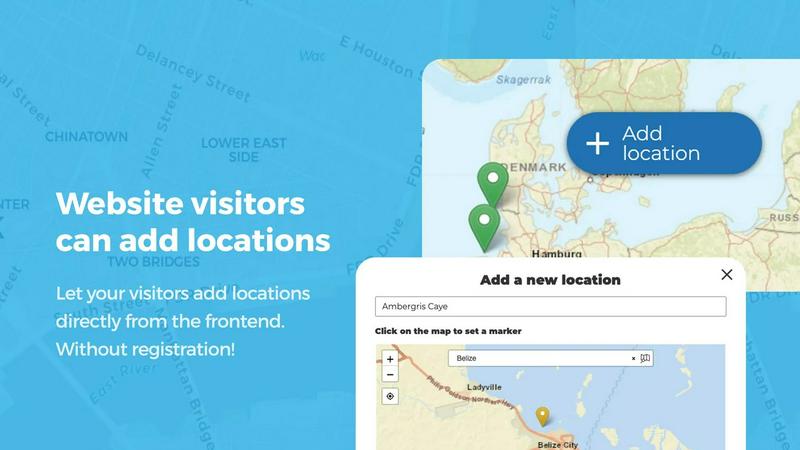
This feature allows any website visitor to add a new location to the map by clicking an 'Add location' button. They can place a marker, fill out a submission form with details, and submit it for review. Crucially, the system includes an approval workflow, meaning the administrator must approve each submission before it becomes publicly visible. Additionally, users can edit their own previously submitted locations, ensuring the map data remains current and accurate over time without requiring administrative intervention for every minor update.
Categorization and Filtering of Markers
Open User Map provides a robust system for organizing map markers into distinct categories, each with its own unique icon. This allows administrators to visually differentiate between types of locations, such as restaurants, parks, and shops. The plugin then enables website visitors to filter the map display by these categories, making it easy to find specific types of points of interest. For added flexibility, a single location can be assigned to multiple categories, ensuring it appears in all relevant filter results.
Lines and Areas Mapping
This feature extends the plugin's capabilities beyond simple point markers. Administrators and contributors can draw lines, routes, paths, zones, and regions directly onto the map. This is ideal for highlighting hiking trails, service areas, event grounds, construction zones, or any custom polygon shape. The system automatically calculates distances for lines and area sizes for polygons, providing useful measurements directly within the map interface. This functionality is demonstrated in a dedicated demo on the plugin's website.
Custom Image as Map
Open User Map allows you to upload any image and convert it into a fully interactive map. This is perfect for scenarios where a traditional geographical map is not suitable, such as for floor plans, event layouts, game maps, product diagrams, campus guides, or seating charts. Users can place markers directly on the uploaded image, and it supports the same powerful features as a standard map, including custom fields, filtering, and a clickable experience. This provides a highly tailored mapping solution for specific visual contexts.
Use Cases
Local Business and Service Directories
A city tourism board or local business association can use Open User Map to create a comprehensive directory of restaurants, shops, hotels, and services. Visitors can submit new businesses they discover, add reviews or descriptions via custom fields, and filter the map by category (e.g., "Italian restaurants" or "Cafes"). The approval workflow ensures only accurate and vetted businesses are listed, while the star rating feature allows the community to highlight the best establishments.
Community Resource and Event Mapping
Non-profit organizations or community groups can deploy this plugin to map resources like food banks, community gardens, public Wi-Fi hotspots, or upcoming local events. Residents can contribute by adding new resources or updating information for existing ones. The lines and areas feature can be used to define service zones or event boundaries, while the upvote/like system helps identify the most popular or critical resources, fostering a sense of community involvement and shared data ownership.
Real Estate and Property Showcasing
Real estate agents and property management companies can use Open User Map to display available properties for sale or rent. Each property can be a marker with custom fields for price, number of bedrooms, square footage, and property type. Potential buyers can filter by these fields to quickly find suitable options. The custom image map feature can be used to show a plot of land with proposed building layouts or a floor plan of an apartment building with units marked as available or sold.
Educational and Campus Guides
Schools, universities, and large corporate campuses can utilize the custom image map feature to create an interactive guide of their facilities. An uploaded campus map or floor plan becomes a clickable interface where students or employees can find buildings, classrooms, labs, cafeterias, and parking lots. Administrators can add markers for specific events or temporary closures, and the filtering system allows users to quickly locate key amenities like restrooms, IT support, or emergency exits.
Frequently Asked Questions
Do I need a Google Maps API key to use Open User Map?
No, you do not need a Google Maps API key. Open User Map is designed to work without one, eliminating a common source of complexity and potential cost for website owners. The plugin uses its own mapping infrastructure, allowing for a straightforward setup process.
How does the approval workflow for user submissions work?
When a visitor submits a new location, it is placed in a pending state, not visible on the public map. The website administrator receives a notification and can review the submission from the WordPress dashboard. The admin can then approve, edit, or reject the submission. Once approved, the location becomes publicly visible on the map.
Can I customize the information collected from users when they add a location?
Yes, the plugin offers flexible custom fields. You can add text boxes, links, checkboxes, and dropdown menus to the submission form. This allows you to gather specific information relevant to your map, such as a business's website URL, opening hours, or a short description, tailoring the data collection to your exact needs.
Is the PRO version a one-time purchase or a subscription?
The provided context does not specify the exact pricing model for the PRO version (one-time fee vs. subscription). However, it is clearly stated that a 7-day free trial is available with no credit card required. The trial does not automatically convert into a paid subscription, allowing users to evaluate the full feature set without financial commitment. For specific pricing details, users should visit the official Open User Map website.
Similar to Open User Map

Built2WinWeb AI SEO
Custom PHP websites, AI Indexing Pack ($599 one‑time), and WebAgentScan SaaS ($9/mo). MCP, A2A, llms.txt, full ownership.

saasgrow.ai
saasgrow.ai is a curated directory of SaaS growth tools where every listing is screened before it goes live and placement can't be bought.

Huebert
Huebert is a UI color scheme generator that turns your ideas into accessible UI color schemes and beautiful shadcn/ui themes - instantly.
Unifyca
Unifyca is a unified platform for managing, auditing, and backing up client WordPress sites with centralized documentation and credentials.

Shadcn Examples
Shadcn Examples offers comprehensive React and Tailwind UI kits with reusable components for building modern web applications efficiently.

What Time
WhatTime.dev is a comprehensive tool that simplifies time zone comparisons and meeting planning for global teams and remote workers.

Webleadr
Webleadr helps you effortlessly find and contact web design leads and businesses without websites from anywhere in just a few clicks.

SiteMd
SiteMD is a comprehensive website health scanner that provides detailed SEO, performance, and security audits with plain-English reports.